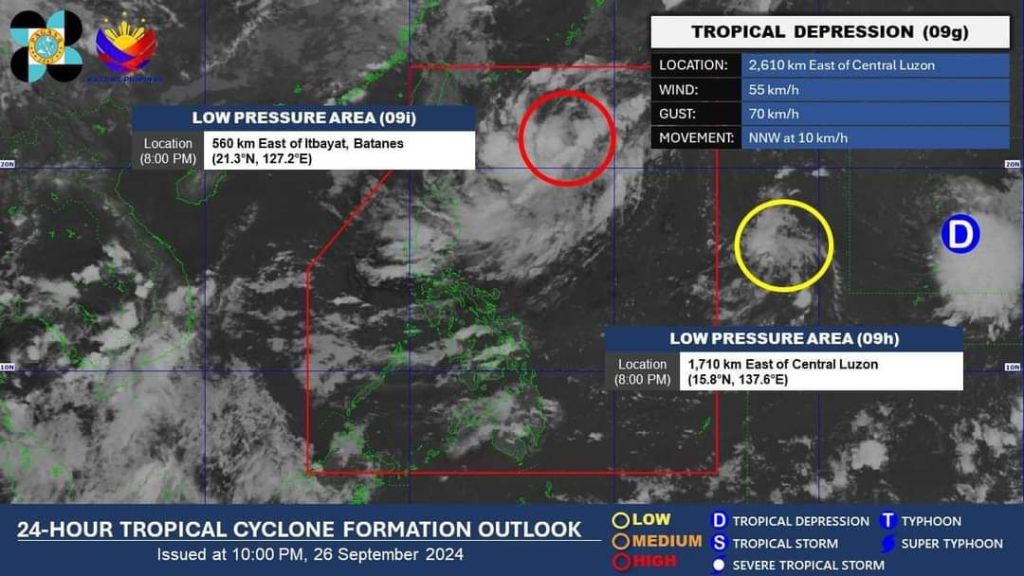
The Philippine Atmospheric, Geophysical and Astronomical Services Administration (PAGASA) is closely monitoring cloud clusters inside the country’s area of responsibility as a tropical cyclone may develop by the weekend.
The state weather bureau said the cloud clusters may strengthen into a tropical cyclone over the weekend – which may then be given the name “Julian” as the 10th cyclone to affect the Philippines since January.
“Kung saka-sakaling makaapekto po ito, more on mga areas lamang po sa Northern Luzon. At kung sakaling magiging bagyo ay bibigyan natin ito ng pangalan na ‘Julian’ na siyang magiging pang-sampung bagyo na for this year 2024 at pang-anim naman po for the month of September,” said PAGASA specialist Benison Estareja during an early morning weather report.
Meanwhile, a low-pressure area (LPA) outside the country’s area of responsibility was located around 2,700 kilometers east of Central Luzon.
PAGASA said that while the LPA is unlikely to enter the country, it may strengthen into a weak storm within the next 24 to 48 hours as it moves towards the northern part of the Pacific Ocean.
The Inter-Tropical Convergence Zone (ITCZ) will continue to affect Palawan, Visayas, and Mindanao, bringing cloudy skies and isolated rains to these areas, according to the state weather bureau.
Residents in Mindanao, particularly in Zamboanga Peninsula, Northern Mindanao, and Caraga, were also advised to prepare for localized thunderstorms and scattered rain showers within the next 24 hours.
- Marcos orders probe, protection over child’s abuse report
- SSS posibleng magpapatupad ng loan moratorium at penalty condonation.
- TNVS DRIVER, NAG-AALOK NG LIBRENG SAKAY PARA SA MGA ESTUDYANTE AT PASYENTE
- PAMILYA SA CAMARINES SUR, GUMAWA NG DIY NA PARAAN PARA MATULUNGAN ANG MAY SAKIT NA AMA
- Robredo on 2028 elections: Hindi pa umiinit yung upuan ko, tapos pulitika agad?

Leave a comment